
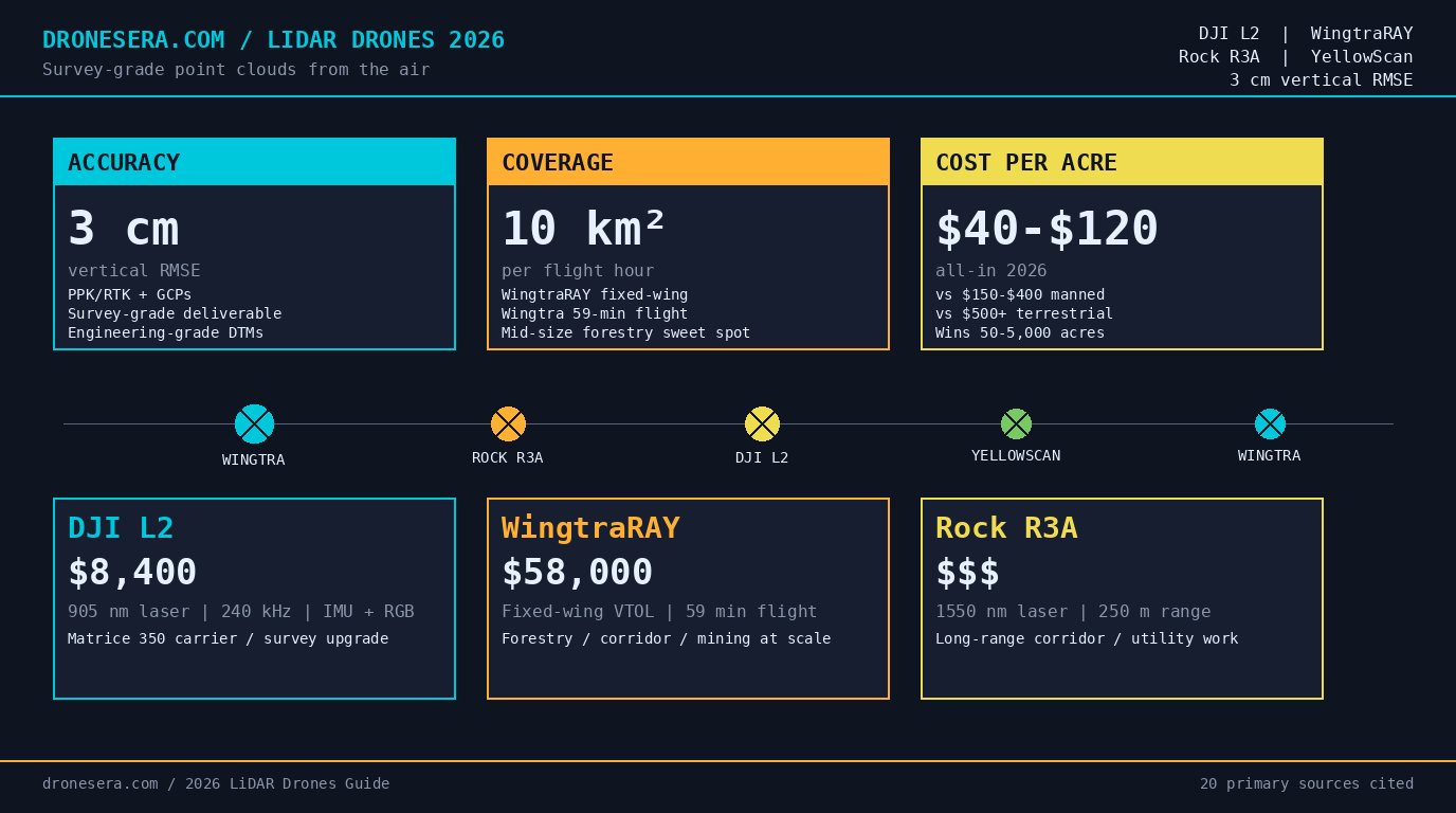
Drone-mounted LiDAR is no longer exotic in 2026. The hardware stack has matured into commodity survey gear: a 905 nm or 1550 nm laser scanner bolted to a stabilized IMU, a multi-frequency GNSS receiver for PPK/RTK post-processing, and a vertical-landing airframe capable of 30-50 minute missions over a square mile of terrain. The result is a survey-grade point cloud delivered in days instead of weeks, at a per-acre cost that undercuts manned aerial LiDAR for most mid-size jobs.
This guide covers the working principle behind drone LiDAR, the 2026 hardware landscape (DJI L2, WingtraRAY, Rock R3A, YellowScan Mapper+), the accuracy bands each platform delivers, and the use cases where drone LiDAR is genuinely the right tool – forestry and biomass, corridor mapping, mining volumetrics, and construction site surveys. We close with cost-per-acre comparisons against manned aerial and terrestrial scanning, and the FAA Part 107 waiver considerations for night operations.
If you’re sizing a LiDAR survey for a project, you should walk away with a clear sense of which platform fits your accuracy and footprint needs, and which use cases are worth the investment. For readers also weighing commercial drone careers, our FAA Part 107 guide covers the certification pathway that every LiDAR survey crew lead needs to hold.
How Drone-Mounted LiDAR Actually Works
A drone LiDAR system fires laser pulses at a rapid cadence – typically 100 kHz to 1.2 MHz – and measures the round-trip time of each returned pulse. Combined with the precise orientation of the laser (from an inertial measurement unit) and the position of the airframe (from a GNSS receiver), every return resolves to a 3D coordinate in space. The collection of those coordinates is the point cloud.
Three pieces make the system work:
1. **The laser scanner.** Emits near-infrared pulses (most commonly 905 nm, with 1550 nm used for eye-safe long-range systems) and detects returns. Modern scanners measure multiple returns per pulse – useful in forestry, where the first return is canopy and later returns are branches and ground. The pulse repetition rate drives point density at a given flight speed and altitude.
2. **The IMU.** Tracks orientation of the laser at sub-arcsecond precision. Survey-grade IMUs cost more than the rest of the payload combined and are the single biggest driver of system price. The IMU is what turns a stream of range measurements into a usable point cloud; without it, the data is geometric noise.
3. **The GNSS receiver.** Logs raw satellite observations for post-processing. PPK (Post-Processed Kinematic) corrects the trajectory after the flight using base-station logs, while RTK (Real-Time Kinematic) corrects in real time using a network or local base. Both deliver centimeter-level trajectory accuracy; PPK is more robust in remote areas without cellular coverage.
The LiDAR equation in practice: a DJI L2 flown at 100 m AGL with RTK fix will produce roughly 240 returns per square meter at 12 m/s ground speed. The same airframe with a YellowScan Mapper+ at the same altitude produces ~500 returns/m² with five returns per pulse. The differences matter for canopy penetration and ground-point density in forestry.
A useful framing is that the laser scanner is the loudhailer and the IMU is the directional microphone – without the IMU, you can shout all you want and you still won’t know where the echo came from.
For the underlying physics and a longer history of LiDAR, the Wikipedia overview at the LiDAR article is a useful reference. The Point cloud entry covers the data format side.
The GNSS side of this stack overlaps directly with the precision-landing systems used in autonomous drone platforms. Our guide to autonomous precision landing with VPS and RTK covers the same RTK correction workflow in the landing context, with worked examples for the ZED-F9P and ZED-X20D receivers that show up in both LiDAR and precision-landing payloads.
The 2026 Hardware Landscape: DJI L2, WingtraRAY, Rock R3A, YellowScan
Four platforms dominate drone LiDAR in 2026. The choice comes down to mission type, accuracy requirement, and budget.
DJI L2
The L2 is DJI Enterprise’s second-generation aerial LiDAR sensor, built on the Livox Mid-360 laser module (Livox spec sheet). It integrates a 905 nm laser with a 30° circular scan pattern, an IMU, and a 20 MP RGB mapping camera for colorizing the point cloud. At $8,400 retail, it is the most accessible survey-grade LiDAR on the market.
Vertical accuracy with PPK and ground control: 3 cm RMSE at 100 m AGL. Point rate: 240 kHz effective. Coverage at typical survey speed: 2.5 km² per flight hour for general terrain, ~1.5 km² per flight hour in dense canopy where you need multiple returns.
Best for: survey firms running Matrice 350 fleets who want a LiDAR upgrade path without swapping airframes.
WingtraRAY
Wingtra’s WingtraRAY fixed-wing VTOL is purpose-built for mapping and offers a fully integrated LiDAR+RGB bundle at $58,000 for the post-processed mapping kit. Coverage is 4-5× larger than quadcopter platforms per flight: 10 km² per flight hour at 120 m AGL.
Vertical accuracy with Wingtra’s built-in PPK: 3 cm RMSE. Point density: 80-100 points/m². Flight time: up to 59 minutes per battery.
Best for: forestry, corridor, and mining projects where the per-flight footprint dominates cost.
Rock R3A
The Rock R3A is the long-range specialist. It uses a 1550 nm eye-safe laser, giving it 50% longer range than 905 nm systems at equivalent aperture. Effective range: 250 m at 80% target reflectivity. Vertical accuracy: 5-8 cm RMSE without ground control, 3 cm with GCPs.
Best for: powerline and pipeline corridor surveys where longer standoff range translates to faster ground coverage and lower collision risk with infrastructure.
YellowScan Mapper+
YellowScan’s Mapper+ is the integrator-grade workhorse. It is a payload, not a complete airframe – designed to mount on DJI M300/M350 or larger fixed-wing platforms. Point rate up to 500 kHz, multi-return capable. Vertical accuracy: 2-3 cm RMSE with PPK.
Best for: survey firms that already operate a fleet and want a LiDAR payload that works on multiple airframes. The YellowScan product page includes integration notes and pricing.
The 2026 market for these systems is growing at a roughly 20% CAGR according to MarketsandMarkets’ drone LiDAR report, with Goldstein Research pegging 2026 global revenue at $1.4B.
Accuracy Bands – What PPK and RTK Actually Buy You
Vertical accuracy is the headline number surveyors care about. Drone LiDAR vendors quote three numbers:
- **Without PPK/RTK or ground control** – 20-50 cm vertical RMSE. Useful for rough cut/fill estimates and forestry stand delineation. Not survey grade.
- **With PPK/RTK, no GCPs** – 5-15 cm vertical RMSE. Acceptable for forestry biomass estimation and corridor planning, not for engineering-grade deliverables.
- **With PPK/RTK and GCPs** – 2-5 cm vertical RMSE. Engineering-grade. Required for FEMA floodplain work, transportation design, and mining volumetrics.
The difference between PPK and RTK is workflow, not accuracy. RTK uses a live correction stream – typically from a network RTK provider (e.g., SmartNet, VRS) – and gives the operator immediate confidence that the trajectory is fixed. PPK records raw GNSS observations on the drone and at a base station, then resolves the trajectory after the flight using software like POSPac or TerraPos. In remote areas without cellular coverage, PPK is the only option. In urban areas with good network RTK coverage, RTK saves the post-processing step.
A practical rule: budget one full working day of post-processing per flight hour. A typical forestry survey with 4 flight hours produces a point cloud in 4-6 hours of operator time plus 1-2 hours of QA review.
For FAA night operations, drone LiDAR has a unique advantage over photogrammetry: it does not require ambient light. The laser is its own illumination source. This is why most forestry LiDAR is flown at night – cooler air, less wind, and no sun-angle constraint on flight lines. The waiver process is documented in the FAA’s Part 107 commercial operators portal, and the relevant night-operations rule is in the 14 CFR Part 107 text at Section 107.29.
For international readers operating under non-US regulators, the drone pilot certifications comparison covers how FAA, EASA, and CAAC diverge on commercial drone licensing, with night-operations waiver differences documented across all three jurisdictions.
Best Use Cases: Where Drone LiDAR Beats Manned Aerial
Drone LiDAR is not the right tool for every job. It wins decisively in five scenarios and loses in three.
Where drone LiDAR wins
- **Mid-size forestry and biomass** (50-5,000 acres). Cost per acre is roughly 1/3 of manned aerial LiDAR for the same accuracy band.
- **Corridor mapping** (powerlines, pipelines, rail). Longer range and lower altitude give higher point density on the linear feature.
- **Active mining and stockpile volumetrics**. Repeat flights every 30-90 days for cut/fill tracking.
- **Construction site progress surveys**. Weekly or bi-weekly flights replace terrestrial scanning for earthworks.
- **Post-disaster response** (wildfire, flooding, earthquake). Rapid mobilization with no runway requirement.
Where drone LiDAR loses
- **County-scale topographic mapping** (>5,000 acres contiguous). Manned aerial LiDAR with a Riegl or Leica sensor is still more cost-effective at this scale.
- **Bathymetric LiDAR** (lake/river bottom). Requires a 532 nm green laser that penetrates water; no current drone LiDAR sensor ships with this wavelength.
- **High-density urban canyons**. GNSS multipath kills trajectory accuracy; terrestrial scanning or SLAM-based mobile mapping is the better tool.
The FAA’s advanced UAS operations portal covers the regulatory pathway for BVLOS, which is increasingly required for the larger survey footprints where drone LiDAR is most cost-competitive. The Part 108 BVLOS rule that moved through OIRA in 2026 specifically names surveying and mapping as a priority use case – our BVLOS operations primer covers the operator-side changes that come with the rule.
For a related comparison on a different drone application class, our guide to the agricultural drone market 2026 walks through the same kind of multi-platform, multi-vendor analysis for spray drones that this article does for LiDAR drones.
Forestry and Biomass: The Volume-Mapping Sweet Spot
Forestry is the canonical drone LiDAR use case and accounts for roughly half of all drone LiDAR revenue globally in 2026. The reason is straightforward: a forestry stand is impenetrable to photogrammetry from above, but a 1550 nm laser pulse penetrates multiple canopy layers and returns ground points even under dense conifer cover.
A typical forestry LiDAR deliverable is a digital terrain model (DTM) plus a canopy height model (CHM) plus per-tree segmentation. From the CHM, foresters derive stem count, basal area, and biomass volume. The USGS 3D Elevation Program (3DEP) publishes the national standard for forestry-grade LiDAR, and most state forestry agencies now accept drone-acquired LiDAR at QL2 (12 points/m²) for stand-level inventory work.
Forestry drone LiDAR is dominated by fixed-wing platforms (Wingtra, Trinity, Event 38) because of the per-flight footprint. A WingtraRAY at 120 m AGL covers ~10 km² per flight hour and produces a DTM that passes the 3DEP QL2 spec with no GCPs required if PPK is configured correctly.
For coastal and riparian forestry, NOAA’s Digital Coast publishes best practices and hosts LiDAR-derived canopy data that drone-acquired surveys can be calibrated against.
Corridor Mapping: Powerlines, Pipelines, and Rail
Corridor mapping is the second-largest drone LiDAR use case. The metric that matters is point density on the linear feature, which is driven by:
- **Flight speed** (slower = more points per meter on the line)
- **Standoff distance** from the corridor centerline (closer = higher point density, but more collision risk)
- **Laser pulse rate** (higher = more points per pulse)
A Rock R3A at 80 m standoff distance from a 100 km powerline survey, flying at 10 m/s, delivers ~150 points/m² on the conductors and ground – enough to identify conductor sag, vegetation encroachment, and tower geometry. The 1550 nm wavelength is eye-safe at the longer standoff range, which is why Rock Robotic designed the R3A specifically for utility work.
For pipeline and rail, the same logic applies. The deliverable is typically a classified point cloud plus a 1 m buffer DTM along the corridor centerline. Survey firms that previously subcontracted manned aerial LiDAR for corridor work have largely in-sourced it via drone LiDAR in the past three years – the unit economics are that lopsided.
Mining, Stockpile, and Construction Volumetrics
Mining and construction are the third pillar. The math is straightforward: drone LiDAR flies a site in 20-40 minutes and produces a classified point cloud with centimeter vertical accuracy. Volume calculations between two epochs (e.g., end-of-month and start-of-month stockpile) yield cut/fill numbers within 1-3% of true volume – better than the surveyor’s tape-and-prism method and orders of magnitude faster.
Typical mine site revisit cadence:
- **Active pit face**: weekly
- **Stockpile volumetrics**: monthly
- **Tailings dam monitoring**: monthly
- **End-of-month financial reporting**: monthly
- **Permit compliance topography**: quarterly or as required
Construction site progress surveys are similar but with weekly or bi-weekly cadence. A 50-acre construction site takes ~25 minutes to fly with a DJI M350 + L2 at 80 m AGL and produces a classified point cloud suitable for cut/fill, subgrade elevation checks, and progress photos via the integrated RGB camera.
Software and Workflow: From Point Cloud to Deliverable
The LiDAR sensor produces raw data; the value is in the processed deliverable. The 2026 software stack has consolidated around a few names:
- **Pix4Dmatic** – LiDAR-focused processing pipeline. Trajectory adjustment, point cloud generation, classification, DTM/DSM export. Pix4Dmatic product page
- **Bentley Terra** – heavy-duty processing for corridor and mining work. Terra by Bentley
- **LAStools** (rapidlasso) – the reference open-source LiDAR processing suite
- **CloudCompare** – open-source point cloud viewer and classifier
A standard forestry workflow: 1. PPK trajectory adjustment (POSPac or TerraPos) – 30 minutes per flight 2. Laser data georeferencing and point cloud generation (Livox Viewer, WingtraHub, or vendor tool) – 30 minutes 3. Classification (ground vs non-ground) (LAStools, Pix4Dmatic) – 30 minutes 4. DTM/CHM generation (LAStools `lasthin` + `lasgrid`) – 15 minutes 5. Per-tree segmentation (lidR in R, or commercial) – 1-2 hours 6. QA review and deliverable export – 1-2 hours
Total operator time per flight hour: roughly 4-6 hours. A two-person survey crew typically processes 2-3 flight hours of data per working day, which sets the throughput ceiling for any drone LiDAR survey operation.
For processing software that runs locally, the standard workstation is a 16-core CPU with 64 GB RAM and an NVIDIA RTX-class GPU. Cloud processing is available from most vendors but adds per-acre processing cost and is rarely worth it for projects under 5,000 acres.
Cost Per Acre: Drone LiDAR vs Manned Aerial in 2026
The cost-per-acre comparison is where drone LiDAR earns its keep. All-in costs (sensor depreciation, drone rental, operator time, processing, deliverable production) in the contiguous US in 2026:
| Method | Cost per acre | Best fit |
|---|---|---|
| **Drone LiDAR** (DJI L2, WingtraRAY, R3A) | $40-$120 | 50-5,000 acres |
| **Manned aerial LiDAR** (Reigl, Leica) | $150-$400 | 1,000+ acres contiguous |
| **Terrestrial laser scanning** (Reigl, Leica) | $500-$2,000+ | <50 acres, vertical detail critical |
| **Drone photogrammetry** (no LiDAR) | $10-$30 | Bare-earth, no canopy |
Numbers are 2026 US averages from integrator quotes and MarketsandMarkets industry analysis. Actual pricing varies by region, terrain, and required accuracy band.
The break-even where drone LiDAR loses to manned aerial is around 5,000-10,000 contiguous acres. Above that, the fixed mobilization cost of manned aerial ($15,000-$25,000 per mobilization) is amortized over a much larger area. Below 50 acres, terrestrial scanning wins for vertical detail (e.g., building facades, structural steel, accident reconstruction).
For a 500-acre forestry project in the eastern US, drone LiDAR at $80/acre delivers a survey-grade DTM for ~$40,000 all-in. Manned aerial LiDAR would run $120,000-$200,000 for the same deliverable. Terrestrial scanning is not feasible at this footprint.
For a 2,000-acre powerline corridor, drone LiDAR runs $100,000-$160,000 all-in vs manned aerial at $300,000-$800,000. The corridor’s linear geometry favors drone LiDAR – slower flight speed, denser point spacing on the line.
For a 10,000-acre county-wide DTM update, manned aerial LiDAR wins on unit economics. Drone LiDAR would require 25-50 flight days and the processing would dominate the timeline.
The cost analysis framework is similar to the one we used in our drone delivery healthcare 2026 ROI analysis: when per-unit cost falls below a threshold, the unit economics shift the entire market. Drone LiDAR crossed that threshold for mid-size forestry and corridor work in 2022-2023; the 2026 market data confirms the trend has continued.
For an even broader cost-per-acre frame, our guide on drone light show vs fireworks 2026 walks through a similar unit-economics analysis for entertainment drone applications, where the same threshold dynamic drove drone adoption at a different cost scale.
Frequently Asked Questions
How accurate is a drone-mounted LiDAR sensor in 2026?
Survey-grade systems like the DJI L2 and WingtraRAY deliver 3 cm vertical RMSE with PPK/RTK and ground control. Corridor-grade systems like the Rock R3A deliver 5-8 cm at longer standoff range. Accuracy depends primarily on the IMU grade, GNSS processing workflow, and density of ground control points. Without PPK/RTK or GCPs, expect 20-50 cm vertical RMSE – useful for rough cut/fill estimates but not engineering-grade.
Can drone LiDAR see through vegetation?
Yes, partially. Near-infrared laser pulses (905 nm or 1550 nm) penetrate forest canopy and return multiple echoes per pulse, allowing the point cloud to capture both the canopy surface and the bare-earth ground below. Dense canopy with multiple layers can still leave gaps where no ground returns register. For forestry deliverables, expect 50-90% ground-point coverage depending on stand density and season (leaf-off deciduous surveys get more ground returns).
What is the difference between PPK and RTK for drone LiDAR?
RTK (Real-Time Kinematic) uses a live correction stream from a base station or network RTK to correct GNSS positions in real time. PPK (Post-Processed Kinematic) logs raw GNSS data and applies corrections after the flight using base-station logs. PPK is more robust in areas with poor cellular coverage and typically delivers slightly better accuracy on long baselines (>20 km from the nearest base station). Most survey firms use both – RTK as a confidence check during the flight, PPK as the authoritative trajectory.
Do you need a Part 107 waiver to fly LiDAR at night?
Yes. Night operations of small UAS require a waiver under 14 CFR Section 107.29, even if LiDAR does not require visible-light operation. The waiver process is well-established and most LiDAR survey operators carry a standing night waiver with conditions on anti-collision lighting and crew rest. Most forestry LiDAR is flown at night because cooler air reduces IMU drift, winds are calmer, and there’s no sun-angle constraint on flight lines.
How much does a drone LiDAR survey cost per acre in 2026?
All-in costs (sensor, drone rental, processing, deliverables) typically run $40-$120 per acre for forestry and corridor work in the contiguous US. Compared to manned aerial LiDAR at $150-$400 per acre and terrestrial scanning at $500+ per acre for area coverage, drone LiDAR is the cost-per-acre winner for sites between 50 and 5,000 acres. Below 50 acres, terrestrial scanning wins for vertical detail; above 10,000 acres, manned aerial LiDAR wins on unit economics.
Sources
Primary manufacturer and integrator sources used in this article:
- DJI – Livox Mid-360 sensor specs: https://www.livoxtech.com/mid-360
- Wingtra – WingtraOne and WingtraRAY product pages: https://wingtra.com/wingtraone/, https://wingtra.com/wingtraray/
- YellowScan – Mapper+ product page: https://www.yellowscan.com/products/mapper-plus/
- Rock Robotic – R3A product overview: https://www.rockrobotic.com/
- DJI Enterprise – Dock 3 (autonomous drone in a box for survey): https://enterprise.dji.com/dock-3
Regulatory sources:
- FAA Part 107 commercial operators: https://www.faa.gov/uas/commercial_operators/
- 14 CFR Part 107 (eCFR): https://www.ecfr.gov/current/title-14/chapter-I/subchapter-F/part-107
- FAA advanced UAS operations (BVLOS): https://www.faa.gov/uas/advanced_operations/
- FAA UAS portal: https://www.faa.gov/uas/
Software and processing:
- Pix4Dmatic: https://www.pix4d.com/product/pix4dmatic
- Bentley Terra: https://terra.bentley.com/
Government and open data:
- USGS 3D Elevation Program (3DEP): https://www.usgs.gov/3d-elevation-program
- NOAA Digital Coast: https://coast.noaa.gov/digitalcoast/
- OpenTopoData: https://www.opentopodata.org/
Industry analysis:
- MarketsandMarkets – Drone LiDAR market report: https://www.marketsandmarkets.com/Market-Reports/drone-lidar-market
- Goldstein Research – Drone LiDAR market outlook 2026: https://www.goldsteinresearch.com/report/drone-lidar-market-outlook-2026
Background reading:
- Wikipedia – LiDAR overview: https://en.wikipedia.org/wiki/Lidar
- Wikipedia – Point cloud data format: https://en.wikipedia.org/wiki/Point_cloud
For a related cost-per-unit analysis on a different drone application, see our guide on the drone delivery in healthcare 2026 ROI analysis. For more on the broader Part 107 regulatory framework that governs commercial drone operations in the US, see our FAA Part 107 guide.