
Autonomous precision landing is two sensors doing different jobs
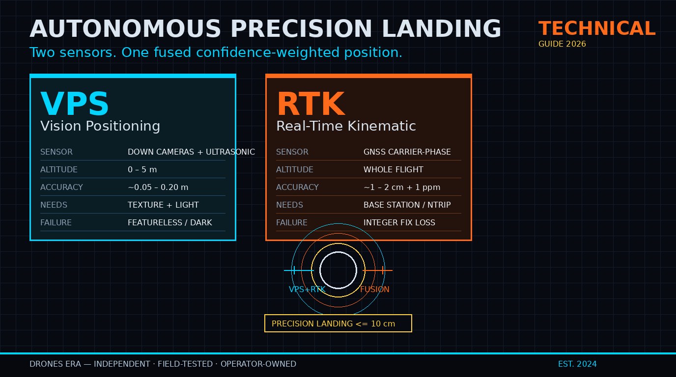
Autonomous precision landing in 2026 is a two-sensor story. Vision Positioning Systems (VPS) handle the last few meters of ground-relative accuracy using downward cameras and ultrasonic ranging, achieving roughly decimeter-class hover stability when the GPS signal is weak or unavailable. Real-Time Kinematic (RTK) handles the broader positioning problem using carrier-phase GNSS corrections from a base station or correction service, achieving centimeter-class horizontal accuracy across the entire flight. The two systems are not redundant — they measure different things — and modern commercial drones use sensor fusion to combine them into a single confidence-weighted position estimate. We have written this guide to explain how each sensor actually works, where the seams are between them, and what to look for if you are buying or building a precision-landing-capable platform.
How VPS works: the last five meters of the descent
VPS is the sensor stack responsible for ground-relative positioning in the moments closest to touchdown. On most consumer and prosumer drones — DJI’s Mavic line, Autel’s Evo line, Skydio’s autonomous platforms — it consists of a pair of downward-facing cameras plus one or more ultrasonic or time-of-flight sensors pointing at the ground. The cameras capture a sequence of frames at high frame rate, the onboard processor runs feature detection on each frame, and the system tracks how those features translate frame-to-frame to estimate the drone’s horizontal motion relative to the takeoff point. The ultrasonic sensor measures altitude above ground.
This is the same visual-odometry technique used in self-driving cars, scaled down and tuned for the roughly 0–5 meter altitude band. The system builds a local map of surface features at takeoff (textures of grass, concrete, decking planks) and tracks drift in real time. When wind pushes the drone sideways, or a pilot nudges the controls, the system recognizes the motion relative to the ground and resists it. In flight tests of recent commercial platforms, VPS-only hover precision when GPS is denied typically lands in the 0.05–0.20 meter range — accurate enough to hand-launch from a balcony, not accurate enough to land on a charging pad without further sensors.
VPS has hard limits. It needs a textured surface to lock onto — uniform pavement, water, or snow under the drone degrade precision badly. It works in low light but degrades sharply in total darkness. It is fooled by moving shadows, and by reflective surfaces that confuse the ultrasonic sensor. Operators caution that VPS-claimed accuracy specs are best-case, and the practical error bands are widest right when you can least afford them: low altitudes over feature-poor terrain.
How RTK works: centimeter accuracy across the whole flight
RTK fixes a fundamentally different problem: where the drone is in absolute Earth coordinates, with centimeter-class accuracy, while flying at altitude. The standard consumer GPS module reports position with roughly 2–3 meter horizontal accuracy under nominal conditions — fine for “stay roughly here,” disastrous for any operation that requires repeatable precision (mapping, surveying, package delivery, autonomous landing on a specific rooftop pad). RTK closes that gap.
RTK works by comparing the carrier-phase signal received by the drone’s GNSS module to the carrier-phase signal received at a stationary base station at known coordinates. The differences in those carrier-phase measurements, sampled at high rate, allow the receiver to estimate the integer number of carrier-phase cycles between the satellite and antenna — the “integer ambiguity resolution.” Once resolved, the relative position between the base and the rover can be computed to centimeter precision. With corrections streaming from a local base, the drone’s horizontal position settles to roughly 1–2 cm plus a few millimeters per kilometer of baseline distance from the base.
Modern RTK hardware lives in modules like the u-blox ZED-F9P or the newer ZED-X20D, both of which are common in commercial drone autopilots. The corrections source is the operational question: a local base station gives free, centimeter-grade corrections but limits the operational radius to the base’s coverage, while a network-based correction service (u-blox PointPerfect is the commercial reference) streams corrections via cellular or satellite IP at modest subscription cost and removes the radius limit. For BVLOS-class operations and commercial delivery, network corrections are now the dominant pattern.
If you are still getting up to speed on the regulatory side, our drone pilot certifications explainer lays out what the FAA, EASA, and CAAC require for legal commercial operations in 2026.
Sensor fusion: how VPS and RTK combine
The interesting design question is how the two sensors merge their estimates. A modern precision-landing autopilot computes a fused position estimate at high frequency, weighting each sensor by its current reliability. At altitude, RTK dominates because VPS has nothing meaningful to lock onto (the ground is too far away, the frame-to-frame motion is dominated by aircraft motion rather than ground-relative motion). During the final approach below roughly five meters altitude, VPS takes over as the primary horizontal reference — RTK is still useful but its error band grows when the aircraft is moving fast vertically, and VPS is reading the surface directly.
Vertically, the sensors divide differently. RTK handles altitude most of the flight (the barometer provides a smooth but drifting measurement, and RTK contributes the absolute altitude reference). The ultrasonic or time-of-flight sensor handles altitude in the last 1–3 meters, where the barometer’s drift matters most and RTK’s vertical precision is typically worse than its horizontal precision (RTK vertical accuracy is roughly 1.5× the horizontal accuracy for most consumer modules). The vision cameras also contribute to altitude estimation in the last few meters as a secondary check on the ultrasonic sensor.
Fusion comes with caveats. RTK requires the integer ambiguity resolution to succeed; if it fails, the system degrades to standard GPS-grade accuracy until corrections re-converge. VPS requires a textured surface; if it does not have one, the system falls back to inertial-only estimation, which drifts. Operators caution that the real-world performance of a precision-landing drone is determined by the worst-case behavior of the fusion logic — what happens when one sensor fails — not by the best-case performance when everything is healthy.
What “precision landing” means in practice
For real-world deployment, precision landing means landing within roughly 10 cm of a designated point — usually a charging pad, a delivery target, or a survey ground control marker. That threshold is set by the size of typical landing hardware: a wireless charging coil is a few tens of centimeters across, and a package drop target is similar. Anything looser than 10 cm and you risk missing the pad entirely or landing in a position that breaks contact with the charger.
Open-source autopilot stacks solve this in two different ways. PX4 supports precision landing on ArUco markers using either the native Vision Target Estimator or an offboard positioning system that streams MAVLink LANDING_TARGET messages from a companion computer or external camera rig; the estimator maintains a position fix even when the marker is briefly occluded. ArduPilot supports precision landing via IR-LOCK sensors for marker-based precision and via MAVLink landing-target streams from companion computers for vision-based precision. The MAVLink protocol standardizes the interface, which is why the same approach works on both stacks.
For consumer prosumer drones, the precision-landing story is simpler and closed. DJI’s recent flagships — including the Mavic 4 Pro — advertise precision landing on a coordinated pad using a combination of vision markers recognized by the lower vision system and RTK-derived position when the platform supports it. The drone finds the pad in its pre-mapped takeoff coordinate, hovers, and descends. The user never touches any of the parameters. For the broader operator-skills context, our drone flight school ranking walks through what the major academies actually teach in 2026.
What to look for if you are buying precision-landing hardware
The two spec lines that matter most are: RTK horizontal accuracy (typically 1 cm + 1 ppm for the rover module) and VPS hover accuracy without GPS (typically 0.1 m vertical, 0.3 m horizontal in manufacturer best-case figures). Treat the VPS numbers as best-case under ideal lighting and surface-texture conditions; the practical error band in low light or over feature-poor ground will be substantially wider. RTK numbers assume the corrections stream is intact and the integer ambiguity resolution has converged; expect a brief period after takeoff where the drone is using standard GPS-grade accuracy while RTK locks in.
If you are building rather than buying, the practical hardware question is which GNSS module to integrate and where the corrections come from. Network-based corrections (PointPerfect, Skylark, and a handful of regional equivalents) win on operational radius; a local base station wins on cost and independence from cellular coverage. For a ground-control point survey workflow, a local base is genuinely the better tool. For anything mobile or long-baseline, network corrections.
Whichever route you take, the underlying lesson is the same: VPS and RTK are not interchangeable, and “precision landing” as a marketing term covers a wide range of real-world capability. The systems that work reliably in commercial settings are the systems that treat both sensors as a stack — with declared fallbacks when one fails — not as a single feature. If you have not sorted out which hobbyist license you need first, the FAA TRUST certificate explainer is the right starting point for US-based pilots.
Frequently asked questions
Do I need RTK for precision landing?
You need either RTK or a high-precision absolute positioning reference plus a vision marker at the landing site. VPS alone gives roughly decimeter-class hover accuracy at low altitudes — useful for hover, not for landing on a specific pad. For repeatable centimeter-class precision, RTK is the practical answer.
How accurate is RTK on a drone?
Industry-standard 1 cm + 1 ppm horizontal accuracy is achievable with high-quality modules and corrections. Vertical accuracy is typically 1.5–2× the horizontal figure. Some consumer drones advertise tighter numbers, but operators caution those are best-case figures and depend on good satellite geometry and a clean correction stream.
Can VPS work without GPS?
Yes. VPS is a self-contained visual-odometry system that uses ground texture and altitude ranging. It works indoors, under GPS-denial, and in environments where satellite reception is poor. The accuracy drops in low light, over feature-poor surfaces, and at high altitudes (above roughly 10 m, the system has too little texture density to maintain a precise estimate).
What is an ArUco marker?
ArUco markers are black-and-white fiducial markers that look like QR codes; each marker has a unique ID and a known size. The PX4 and ArduPilot precision-landing systems use ArUco markers as the visual reference for the landing target — they are easy to print, easy for the camera system to recognize, and standardized across both open-source autopilot stacks.
Does the Mavic 4 Pro have precision landing?
The Mavic 4 Pro combines VPS for ground-relative positioning with the option of RTK for absolute positioning; DJI’s higher-end prosumer platforms support precision landing on a designated pad via the DJI Guidance ecosystem. Operators caution that precision-landing performance on consumer platforms depends on lighting, pad visibility from above, and unobstructed GPS reception in the approach path.
